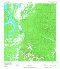
1952 Map of Unalakleet B-1
USGS Topo · Published 1968About this map
The Yukon River dominates this mid-century Alaskan landscape, its wide channel and shifting sandbars defining the western edge of the survey. The complex hydrology of the river is evident in the intricate network of Yokontoh Slough and the presence of Blackburn Island. Moving east from the riverbanks, the terrain transitions into a dense system of drainages, including Papa Willie Creek and Shovel Creek, which carve through the rising elevation toward Dome VABM 1060.
Find a feature on this map
10 named features on this map. Tap any name to fly to it.
Don’t see what you’re looking for? This feature index may not catch every label — zoom into the map to look around manually.
Map Details
Editions of this 1952 Unalakleet B-1 Map
2 editions found
Other maps of this area

1951 · Ophir
USGS Topo · 1:250,000

1951 · Unalakleet
USGS Topo · 1:250,000

1952 · Unalakleet A-2
USGS Topo · 1:63,360

1952 · Unalakleet C-2
USGS Topo · 1:63,360

1952 · Unalakleet A-1
USGS Topo · 1:63,360

1952 · Unalakleet C-1
USGS Topo · 1:63,360

1952 · Unalakleet B-2
USGS Topo · 1:63,360

1952 · Unalakleet B-1
USGS Topo · 1:63,360

1952 · Unalakleet
USGS Topo · 1:250,000

1954 · Ophir A-6
USGS Topo · 1:63,360