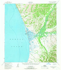
1950 Map of Unalakleet D-4
USGS Topo · Published 1966About this map
Unalakleet sits at the confluence of the Unalakleet River and Norton Sound, serving as a critical coastal hub during the mid-20th century. This survey, compiled from data as early as 1900 and revised in 1966, delineates the bounds of the Unalakleet Native Reservation and the town's essential infrastructure, including a landing area, radio towers, and a Beacon.
Find a feature on this map
31 named features on this map. Tap any name to fly to it.
Don’t see what you’re looking for? This feature index may not catch every label — zoom into the map to look around manually.
Map Details
Editions of this 1950 Unalakleet D-4 Map
2 editions found
Other maps of this area

1948 · Norton Bay
USGS Topo · 1:250,000

1950 · Unalakleet D-3
USGS Topo · 1:63,360

1950 · Norton Bay A-4
USGS Topo · 1:63,360

1950 · Norton Bay A-3
USGS Topo · 1:63,360

1950 · Unalakleet D-4
USGS Topo · 1:63,360

1951 · Unalakleet
USGS Topo · 1:250,000

1951 · Norton Bay
USGS Topo · 1:250,000

1952 · Unalakleet C-3
USGS Topo · 1:63,360

1952 · Unalakleet C-4
USGS Topo · 1:63,360
1952 · Unalakleet C-5
USGS Topo · 1:63,360