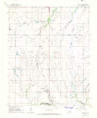
1966 Map of Union City
USGS Topo · Published 1967About this map
Union City serves as a central hub in the mid-1960s, its corporate limits extending north and south along the Chicago Rock Island and Pacific railroad line. The map highlights a community deeply rooted in its local institutions, evidenced by the clustered Union City Cemetery, St Josephs Cemetery, and St Josephs church. To the north, the El Reno corporate boundary marks the transition toward more industrial activity, including Gravel Pits and the Mustang Field area. The landscape is defined by the drainage systems of Sixmile Creek and Arapaho Creek as they flow toward the Canadian River at the southern edge of the survey. Significant for genealogists, several outlying burial grounds like Pleasant View Cemetery and Lutheran Cemetery are documented, alongside rural landmarks such as the Claypit and the settlement at Powers.
Find a feature on this map
22 named features on this map. Tap any name to fly to it.
Don’t see what you’re looking for? This feature index may not catch every label — zoom into the map to look around manually.
Map Details
Editions of this 1966 Union City Map
2 editions found
Other maps of this area

1892 · Kingfisher
USGS Topo · 1:125,000

1893 · Fort Reno
USGS Topo · 1:62,500

1893 · Buggy Creek
USGS Topo · 1:62,500

1893 · Minco
USGS Topo · 1:62,500

1895 · Kingfisher
USGS Topo · 1:125,000

1904 · Chickasha
USGS Topo · 1:125,000

1941 · Fort Reno
USGS Topo · 1:62,500

1942 · Fort Reno
USGS Topo · 1:62,500

1949 · Fort Reno
USGS Topo · 1:62,500

1954 · Oklahoma City
USGS Topo · 1:250,000