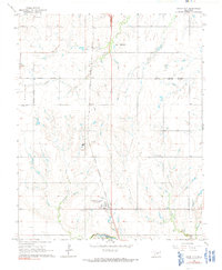
1966 Map of Union City
USGS Topo · Published 1991About this map
Union City serves as the central hub of this mid-1960s landscape, positioned where the Chicago Rock Island and Pacific railroad bisects the Oklahoma Prairie. The area is defined by its agrarian roots and local industry, featuring small extraction sites like a Claypit and several Gravel Pits north near El Reno. To the south, the terrain descends toward the Canadian R, with local drainage provided by Arapaho Cr and Sixmile Creek.
Find a feature on this map
19 named features on this map. Tap any name to fly to it.
Don’t see what you’re looking for? This feature index may not catch every label — zoom into the map to look around manually.
Map Details
Editions of this 1966 Union City Map
2 editions found
Other maps of this area

1892 · Kingfisher
USGS Topo · 1:125,000

1893 · Fort Reno
USGS Topo · 1:62,500

1893 · Buggy Creek
USGS Topo · 1:62,500

1893 · Minco
USGS Topo · 1:62,500

1895 · Kingfisher
USGS Topo · 1:125,000

1904 · Chickasha
USGS Topo · 1:125,000

1941 · Fort Reno
USGS Topo · 1:62,500

1942 · Fort Reno
USGS Topo · 1:62,500

1949 · Fort Reno
USGS Topo · 1:62,500

1954 · Oklahoma City
USGS Topo · 1:250,000