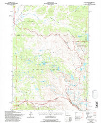
1991 Map of Union Peak
USGS Topo · Published 1997About this map
Union Peak stands as a prominent landmark in this high-altitude landscape where the Continental Divide weaves across the Wind River Range. The 1991 survey reveals a complex network of glacial lakes and drainage basins shared between the Shoshone National Forest, Teton National Forest, and Bridger National Forest. The presence of the Fitzpatrick Wilderness and Bridger Wilderness indicates a strictly managed alpine environment where historical access was primarily defined by foot and pack animal.
Find a feature on this map
39 named features on this map. Tap any name to fly to it.
Don’t see what you’re looking for? This feature index may not catch every label — zoom into the map to look around manually.
Map Details
Editions of this 1991 Union Peak Map
This is the sole edition of this map. No revisions or reprints were ever made.
Other maps of this area

1905 · Younts Peak
USGS Topo · 1:125,000

1907 · Younts Peak
USGS Topo · 1:125,000

1909 · Fremont Peak
USGS Topo · 1:125,000

1955 · Thermopolis
USGS Topo · 1:250,000

1956 · Dubois
USGS Topo · 1:24,000

1956 · Warm Spring Mountain
USGS Topo · 1:24,000

1956 · Fish Lake
USGS Topo · 1:24,000

1958 · Thermopolis
USGS Topo · 1:250,000

1962 · Thermopolis
USGS Topo · 1:250,000
1967 · Fish Creek Park
USGS Topo · 1:24,000