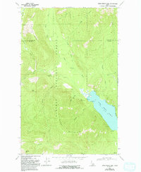
1969 Map of Upper Priest Lake
USGS Topo · Published 1993About this map
Upper Priest Lake dominates the center of this terrain, its shoreline serving as a focal point for the surrounding Kaniksu National Forest. In the late 1960s, this area of Bonner County remained largely defined by its logging and mining history, evidenced by the presence of several prospect sites including the Plowboy Mine, Mountain Chief Mine, and Navigation Mine. These workings are situated near the western shore of the lake, below the heights of Plowboy Mountain. To the north, the Upper Priest River flows through a valley flanked by Hughes Ridge and Gold Peak, where high-altitude infrastructure like the Lookout Tower and Hughes Meadows Fire Station supported forest management. The presence of a Pack Trail and 4wd routes suggests a landscape accessible primarily by boat or primitive road, maintaining the isolation of remote landings like Navigation Campground.
Find a feature on this map
27 named features on this map. Tap any name to fly to it.
Don’t see what you’re looking for? This feature index may not catch every label — zoom into the map to look around manually.
Map Details
Editions of this 1969 Upper Priest Lake Map
4 editions found
Other maps of this area

1911 · Priest Lake
USGS Topo · 1:250,000

1913 · Priest Lake
USGS Topo · 1:250,000

1934 · Metaline
USGS Topo · 1:125,000

1942 · Metaline
USGS Topo · 1:125,000

1958 · Sandpoint
USGS Topo · 1:250,000

1963 · Sandpoint
USGS Topo · 1:250,000

1967 · Priest Lake NE
USGS Topo · 1:24,000

1967 · Salmo Mtn.
USGS Topo · 1:24,000

1967 · Priest Lake NW
USGS Topo · 1:24,000

1967 · Helmer Mtn
USGS Topo · 1:24,000