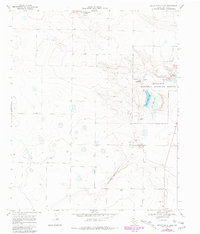
1968 Map of Upper White Lake
USGS Topo · Published 1981About this map
Muleshoe National Wildlife Refuge dominates this section of the High Plains, preserving a chain of saline lakes that characterize the local hydrology. The basin includes Upper White Lake, Lower White Lake, and the Goose Lakes, providing a stark contrast to the surrounding land marked by numerous wells and isolated depressions. To the south, the small settlement of Enochs sits at the intersection of local routes, while the refuge infrastructure is detailed with its Refuge Headquarters, a Campground, and a Landing Strip. The presence of several Gravel Pits and a network of unimproved roads suggests a landscape shaped by both conservation and rural industry. This record includes purple-ink revisions from 1979 aerial photography, showing shifts in the shoreline of Baileyboro Lake and new developments in the terrain over a decade of change.
Find a feature on this map
13 named features on this map. Tap any name to fly to it.
Don’t see what you’re looking for? This feature index may not catch every label — zoom into the map to look around manually.
Map Details
Editions of this 1968 Upper White Lake Map
3 editions found
Other maps of this area

1954 · Clovis
USGS Topo · 1:250,000

1954 · Brownfield
USGS Topo · 1:250,000

1958 · Brownfield
USGS Topo · 1:250,000

1958 · Clovis
USGS Topo · 1:250,000

1962 · Brownfield
USGS Topo · 1:250,000

1962 · Needmore
USGS Topo · 1:24,000

1962 · Stegall
USGS Topo · 1:24,000

1962 · Baileyboro
USGS Topo · 1:24,000
1968 · Bula
USGS Topo · 1:24,000

1968 · Three Way School
USGS Topo · 1:24,000