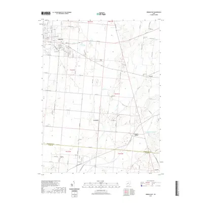
2019 Map of Urbana East
USGS Topo · Published 2019About this map
Urbana serves as the focal point for this survey of Champaign County, where the eastern reaches of the city meet a rural landscape defined by glacial hydrology and small crossroads settlements. A notable series of water bodies, including First Price Pond, Second Price Pond, and Third Price Pond, line the northern corridor along US Rte 36, while the drainage of Dugan Run and Dugan Ditch shapes the central terrain. The map is a significant resource for genealogists, documenting a high density of burial grounds such as Oakdale Cem, Grandview Cem, and Buck Creek Cem. To the southeast, the geography transitions into Clark County, anchored by Catawba and the rural outpost of Catawba Station. This 2019 edition also details more modern infrastructure like Weller Airport and the East Fork Buck Cr Structure Number Four Reservoir, illustrating how water management and aviation have integrated into the older agricultural grid.
Find a feature on this map
105 named features on this map. Tap any name to fly to it.
Don’t see what you’re looking for? This feature index may not catch every label — zoom into the map to look around manually.
Map Details
Editions of this 2019 Urbana East Map
This is the sole edition of this map. No revisions or reprints were ever made.
Other maps of this area

1904 · Springfield
USGS Topo · 1:62,500

1906 · Springfield
USGS Topo · 1:62,500

1907 · South Charleston
USGS Topo · 1:62,500

1914 · St. Paris
USGS Topo · 1:62,500

1914 · Mechanicsburg
USGS Topo · 1:62,500

1916 · Mechanicsburg
USGS Topo · 1:62,500

1916 · St. Paris
USGS Topo · 1:62,500

1944 · Mechanicsburg
USGS Topo · 1:62,500

1944 · St. Paris
USGS Topo · 1:62,500

1947 · Columbus
USGS Topo · 1:250,000