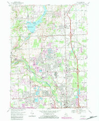
1968 Map of Utica
USGS Topo · Published 1984About this map
Stony Creek Lake and the Rochester-Utica State Recreation Area anchor this landscape during a period of significant suburban expansion between Rochester and Utica. The map documents the intricate drainage network feeding the Clinton River, including the Banister and Wilcox drains, which define the low-lying topography south of Washington. These waterways are interspersed with several gravel pits and the prominent Proving Ground facility near Disco.
Find a feature on this map
49 named features on this map. Tap any name to fly to it.
Don’t see what you’re looking for? This feature index may not catch every label — zoom into the map to look around manually.
Map Details
Editions of this 1968 Utica Map
4 editions found
Other maps of this area

1908 · Rochester
USGS Topo · 1:62,500

1912 · Mt Clemens
USGS Topo · 1:62,500

1914 · Armada
USGS Topo · 1:62,500

1928 · Armada
USGS Topo · 1:62,500

1929 · Mt Clemens
USGS Topo · 1:62,500

1936 · Warren
USGS Topo · 1:31,680

1936 · Birmingham
USGS Topo · 1:31,680

1936 · Rochester
USGS Topo · 1:31,680

1936 · Washington
USGS Topo · 1:31,680

1936 · Waldenburg
USGS Topo · 1:31,680
Featured Places
- Sterling Heights, MI
- Shelby Charter Township, MI
- Rochester Hills, MI
- Washington Charter Township, MI
- Oakland Charter Township, MI