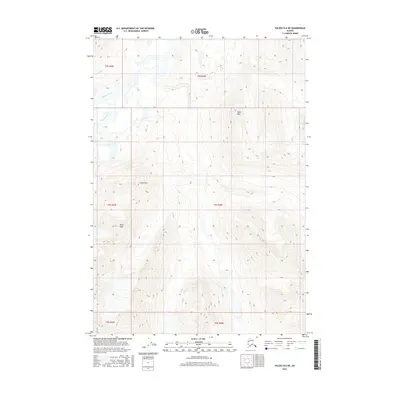
2016 Map of Valdez B-6 NE
USGS Topo · Published 2016About this map
Klutina River flows through this mountainous region of the Unorganized Borough, providing a key hydrological landmark in a landscape defined by significant elevations. The terrain is anchored by several prominent heights, including Black Mtn in the northeast and Camp Mtn further south. To the southwest, the distinctive Sharp Peak rises above the surrounding survey sections, while Stephens Creek drains the northern reaches of the quadrangle. This 2016 survey highlights the raw topographical character of the Alaskan interior, showing the intricate drainage patterns and ridge lines that dictate movement and settlement in the Copper River basin. The map focuses on the physical environment, documenting the relationship between high mountain summits and the river systems that carve through the glacial-carved valleys.
Find a feature on this map
11 named features on this map. Tap any name to fly to it.
Don’t see what you’re looking for? This feature index may not catch every label — zoom into the map to look around manually.
Map Details
Editions of this 2016 Valdez B-6 NE Map
This is the sole edition of this map. No revisions or reprints were ever made.
Other maps of this area

1950 · Valdez C-6
USGS Topo · 1:63,360

1951 · Valdez B-5
USGS Topo · 1:63,360

1951 · Valdez C-5
USGS Topo · 1:63,360

1951 · Valdez B-6
USGS Topo · 1:63,360

1952 · Valdez
USGS Topo · 1:250,000

1953 · Valdez C-6
USGS Topo · 1:63,360

1953 · Valdez C-5
USGS Topo · 1:63,360

1953 · Valdez B-6
USGS Topo · 1:63,360

1960 · Valdez
USGS Topo · 1:250,000
1993 · Valdez C-6
USGS Topo · 1:63,360