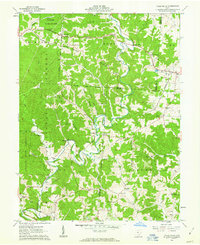
1961 Map of Vales Mills
USGS Topo · Published 1963About this map
Raccoon Creek meanders through the heart of this landscape, anchoring a series of small settlements and milling sites in the early 1960s. The terrain is defined by prominent ridges such as Long Ridge and Chestnut Ridge, where the complex topography of the Zaleski State Forest and Raccoon State Forest meets local agriculture. Small communities like Vales Mills and Bolins Mills hint at a local economy once tied to water power, while scattered oil wells and mines point to the region's extraction history. For genealogists, the map is particularly rich in family-named locations and rural infrastructure, including Arbaugh Cem, Gregory Cem, and Wilton Sch. The presence of several churches, such as Putnam Chapel and Harkins Chapel, underscores the importance of these small social centers in Vinton and Meigs Counties during this era.
Find a feature on this map
58 named features on this map. Tap any name to fly to it.
Don’t see what you’re looking for? This feature index may not catch every label — zoom into the map to look around manually.
Map Details
Editions of this 1961 Vales Mills Map
Other maps of this area

1903 · Athens
USGS Topo · 1:62,500

1904 · Zaleski
USGS Topo · 1:62,500

1905 · Athens
USGS Topo · 1:62,500

1905 · Wilkesville
USGS Topo · 1:62,500

1907 · Pomeroy
USGS Topo · 1:62,500

1907 · Zaleski
USGS Topo · 1:62,500

1908 · Wilkesville
USGS Topo · 1:62,500

1947 · Columbus
USGS Topo · 1:250,000

1960 · Albany
USGS Topo · 1:24,000

1960 · Rutland
USGS Topo · 1:24,000