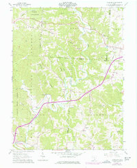
1961 Map of Vales Mills
USGS Topo · Published 1977About this map
Raccoon Creek carves a deep, winding course through this rural pocket of Vinton and Meigs counties, dictating the placement of small agricultural and milling settlements. The map illustrates a landscape transitioning into the 1960s and 1970s, where traditional nodes like Vales Mills and Bolins Mills persist alongside the industrial markers of energy extraction, including several Mines and a Gas Well. The terrain is characterized by high ridges such as Knox Ridge and Chestnut Ridge, where small community centers once flourished around locations like the Wilton Sch and numerous country churches.
Find a feature on this map
53 named features on this map. Tap any name to fly to it.
Don’t see what you’re looking for? This feature index may not catch every label — zoom into the map to look around manually.
Map Details
Editions of this 1961 Vales Mills Map
Other maps of this area

1903 · Athens
USGS Topo · 1:62,500

1904 · Zaleski
USGS Topo · 1:62,500

1905 · Athens
USGS Topo · 1:62,500

1905 · Wilkesville
USGS Topo · 1:62,500

1907 · Pomeroy
USGS Topo · 1:62,500

1907 · Zaleski
USGS Topo · 1:62,500

1908 · Wilkesville
USGS Topo · 1:62,500

1947 · Columbus
USGS Topo · 1:250,000

1960 · Albany
USGS Topo · 1:24,000

1960 · Rutland
USGS Topo · 1:24,000