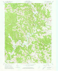
1961 Map of Vales Mills
USGS Topo · Published 1973About this map
Raccoon Creek meanders through a landscape defined by the intersection of Vinton, Athens, and Meigs counties in southeastern Ohio. The area is characterized by high ridges such as Knox Ridge and Union Ridge, which host numerous local landmarks including Putnam Chapel and Harkins Chapel. Small settlements and milling sites are scattered throughout the valley, with Vales Mills and Bolins Mills serving as central points for the surrounding rural community. The presence of several Oil Wells and a Gas Well indicates the active extraction of natural resources during this period.
Find a feature on this map
48 named features on this map. Tap any name to fly to it.
Don’t see what you’re looking for? This feature index may not catch every label — zoom into the map to look around manually.
Map Details
Editions of this 1961 Vales Mills Map
Other maps of this area

1903 · Athens
USGS Topo · 1:62,500

1904 · Zaleski
USGS Topo · 1:62,500

1905 · Athens
USGS Topo · 1:62,500

1905 · Wilkesville
USGS Topo · 1:62,500

1907 · Pomeroy
USGS Topo · 1:62,500

1907 · Zaleski
USGS Topo · 1:62,500

1908 · Wilkesville
USGS Topo · 1:62,500

1947 · Columbus
USGS Topo · 1:250,000

1960 · Albany
USGS Topo · 1:24,000

1960 · Rutland
USGS Topo · 1:24,000