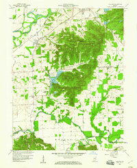
1959 Map of Vallonia
USGS Topo · Published 1977About this map
The East Fork White River and Muscatatuck River define the floodplains of this Jackson County landscape, where the flat, drained agricultural lands of the west meet the wooded uplands of the Jackson-Washington State Forest. The historic settlement of Vallonia serves as a central hub, while the village of Brownstown is situated in the north. The presence of the Hoosier National Forest (Nursery) and the Experimental Farm Ponds indicates a mid-century focus on conservation and agricultural research. Local genealogy is well-represented through numerous family burial grounds such as Miller Cem, Weathers Cem, and Burrell Cem, alongside community landmarks like Driftwood Ch and the school and cemetery at Wegan. The Baltimore and Ohio railroad cuts across the northwest, providing a vital transport link for these rural townships during the late 1950s.
Find a feature on this map
47 named features on this map. Tap any name to fly to it.
Don’t see what you’re looking for? This feature index may not catch every label — zoom into the map to look around manually.
Map Details
Editions of this 1959 Vallonia Map
4 editions found
Other maps of this area

1951 · Smedley
USGS Topo · 1:24,000

1953 · Kossuth
USGS Topo · 1:24,000

1956 · Vincennes
USGS Topo · 1:250,000

1956 · Louisville
USGS Topo · 1:250,000

1957 · Vincennes
USGS Topo · 1:250,000

1958 · Vincennes
USGS Topo · 1:250,000

1958 · Little York
USGS Topo · 1:24,000

1958 · Brownstown
USGS Topo · 1:24,000

1958 · Seymour
USGS Topo · 1:24,000
1959 · Vallonia
USGS Topo · 1:24,000