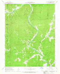
1965 Map of Van Buren North
USGS Topo · Published 1966About this map
The Current River meanders through this portion of the Ozarks, defining the topography of the Mark Twain National Forest and the Peck Ranch State Wildlife Management Area. Small rural settlements like Beal and Norwood are situated near the waterways, while the landscape is heavily dissected by numerous hollows, including Stiffhouse Hollow, Douglas Hollow, and Dusenberry Hollow. The map reveals the distribution of early community centers, marked by several family and local burial sites such as Collins Cem, Maberry Cem, and Reed Cem, along with the Bible Ch. Near the southern edge, the map captures the northern outskirts of Van Buren, including a local sewage disposal pond and Richbark Cave, showing the early 1960s footprint of this river town before modern expansion. This survey illustrates a landscape where life was tightly oriented around spring-fed creeks and the primary river corridor.
Find a feature on this map
57 named features on this map. Tap any name to fly to it.
Don’t see what you’re looking for? This feature index may not catch every label — zoom into the map to look around manually.
Map Details
Editions of this 1965 Van Buren North Map
4 editions found
Other maps of this area

1928 · Cardareva
USGS Topo · 1:62,500

1943 · Ellington
USGS Topo · 1:62,500

1944 · Van Buren
USGS Topo · 1:62,500

1944 · Grandin
USGS Topo · 1:62,500

1945 · Ellington
USGS Topo · 1:62,500

1946 · Grandin
USGS Topo · 1:62,500

1946 · Van Buren
USGS Topo · 1:62,500

1949 · Rolla
USGS Topo · 1:250,000

1949 · Cardareva
USGS Topo · 1:62,500

1953 · Rolla
USGS Topo · 1:250,000