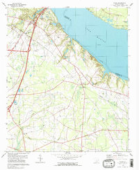
1979 Map of Vance
USGS Topo · Published 1980About this map
Lake Marion and the Santee River dominate the northern landscape of this 1970s coastal plain survey, defining the boundary between Orangeburg and Clarendon counties. The burgeoning town of Santee serves as a gateway to Santee State Park, featuring a developed waterfront with a boat ramp, campgrounds, and a nearby golf course. Inland, the terrain shifts to a network of low-lying wetlands including Horse Range Swamp and Target Swamp, where smaller agricultural settlements and family landmarks are scattered throughout the pine and hardwood bottoms.
Find a feature on this map
39 named features on this map. Tap any name to fly to it.
Don’t see what you’re looking for? This feature index may not catch every label — zoom into the map to look around manually.
Map Details
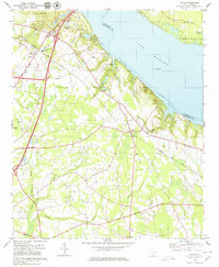
Editions of this 1979 Vance Map
2 editions found
Other maps of this area

1920 · Eutawville
USGS Topo · 1:48,000

1920 · Bowman
USGS Topo · 1:48,000

1921 · Bowman
USGS Topo · 1:62,500

1921 · Eutawville
USGS Topo · 1:62,500

1943 · Bowman
USGS Topo · 1:62,500

1943 · Orangeburg
USGS Topo · 1:125,000

1943 · Eutawville
USGS Topo · 1:62,500

1946 · Elloree
USGS Topo · 1:62,500

1954 · Augusta
USGS Topo · 1:250,000

1957 · Augusta
USGS Topo · 1:250,000