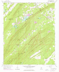
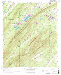
1959 Map of Vandiver
USGS Topo · Published 1978About this map
The Huntsville Meridian serves as a primary reference point for this landscape where Shelby and Jefferson counties meet, defining a region marked by a series of prominent ridges including Coosa Mountain and Double Mountain. The settlement of Vandiver is a central focal point, surrounded by established community landmarks like Union Hill Ch and Pleasant Grove. To the west, the winding course of the Little Cahaba River flows near Lake Purdy, while the central valley is dotted with numerous small water bodies such as Wehapa Lake and Mirror Lakes. Higher elevations are punctuated by infrastructure like the Lookout Tower on Signal Mtn, alongside gaps like Devils Gap and Rattlesnake Gap that dictated local travel through the complex terrain of The Pine Mountain and Straight Ridge.
Find a feature on this map
64 named features on this map. Tap any name to fly to it.
Don’t see what you’re looking for? This feature index may not catch every label — zoom into the map to look around manually.
Map Details
Editions of this 1959 Vandiver Map
5 editions found
Other maps of this area

1889 · Springville
USGS Topo · 1:125,000

1889 · Birmingham
USGS Topo · 1:125,000

1890 · Bessemer
USGS Topo · 1:125,000

1890 · Talladega
USGS Topo · 1:125,000

1892 · Birmingham
USGS Topo · 1:125,000

1892 · Springville
USGS Topo · 1:125,000

1892 · Talladega
USGS Topo · 1:125,000

1892 · Bessemer
USGS Topo · 1:125,000

1895 · Birmingham
USGS Topo · 1:125,000

1905 · Leeds
USGS Topo · 1:62,500