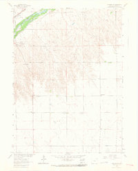
1962 Map of Venango NW
USGS Topo · Published 1964About this map
The South Platte River corridor dominates the northwest corner of this Sedgwick County landscape, where the Union Pacific railroad and Highway 138 follow the river valley's natural path. In the early 1960s, this area served as a critical agricultural and utility hub, featuring the County Fairground and a cluster of Gas Wells and Gravel Pits that supported local infrastructure. Beyond the river valley, the terrain transitions into a grid of rural sections dotted with essential community landmarks like the Liberty Sch and North Plainview Sch. This survey reflects a period of mid-century prairie life where small rural schools still anchored the countryside even as natural resource extraction, evidenced by scattered Gas Wells, began to mark the open plains south of the Julesburg Cem.
Find a feature on this map
16 named features on this map. Tap any name to fly to it.
Don’t see what you’re looking for? This feature index may not catch every label — zoom into the map to look around manually.
Map Details
Editions of this 1962 Venango NW Map
3 editions found
Other maps of this area

1900 · Chappell
USGS Topo · 1:125,000

1952 · Julesburg SE
USGS Topo · 1:24,000

1953 · Julesburg
USGS Topo · 1:24,000

1954 · Sterling
USGS Topo · 1:250,000

1954 · Scottsbluff
USGS Topo · 1:250,000

1958 · Scottsbluff
USGS Topo · 1:250,000

1958 · Sterling
USGS Topo · 1:250,000

1961 · Barton
USGS Topo · 1:24,000

1961 · Big Springs
USGS Topo · 1:24,000

1961 · Chappell SE
USGS Topo · 1:24,000