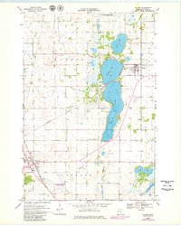
1968 Map of Villard
USGS Topo · Published 1980About this map
The town of Villard sits at the junction of the Northern Pacific railroad and a dense network of glacial lakes, serving as a focal point for the agricultural and recreational landscape of eastern Pope County. Extensive water bodies dominate the terrain, from the large Amelia Lake and Villard Lake to smaller wetlands protected within the Volkmann State Wildlife Management Area. This survey, updated with revisions from the late 1970s, captures the importance of local heritage through several well-marked burial sites, including Lake Leven Cem and St Johns Cem. Further southwest, the edge of Glenwood appears alongside the Glenwood Municipal Airport, indicating the early modern infrastructure supporting this rural corridor. The numerous Gravel Pits scattered near the East Branch Chippewa River highlight the local extractive industries that supported the region's road and rail development.
Find a feature on this map
25 named features on this map. Tap any name to fly to it.
Don’t see what you’re looking for? This feature index may not catch every label — zoom into the map to look around manually.
Map Details
Editions of this 1968 Villard Map
3 editions found
Other maps of this area

1953 · Saint Cloud
USGS Topo · 1:250,000

1957 · Saint Cloud
USGS Topo · 1:250,000

1958 · Saint Cloud
USGS Topo · 1:250,000

1965 · Westport
USGS Topo · 1:24,000

1965 · Sedan
USGS Topo · 1:24,000

1966 · Osakis
USGS Topo · 1:24,000

1966 · Lake Mary
USGS Topo · 1:24,000

1966 · Forada
USGS Topo · 1:24,000

1968 · Glenwood
USGS Topo · 1:24,000

1968 · Terrace
USGS Topo · 1:24,000