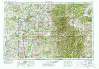
1956 Map of Vincennes
USGS Topo · Published 1978About this map
The Wabash River and White River systems dominate this mid-century look at the tri-state region, where the industrial hub of Evansville anchors the southern landscape and the historic settlement of Vincennes sits at the western border. The eastern half of the map reveals the dense wooded terrain of the Hoosier National Forest and specialized federal sites like the Crane Naval Ammunition Depot. This survey captures the transition from the coal-rich plains of Greene-Sullivan State Forest and active Strip Mine operations to the established agricultural and rail centers of Washington, Jasper, and Bedford.
Find a feature on this map
112 named features on this map. Tap any name to fly to it.
Don’t see what you’re looking for? This feature index may not catch every label — zoom into the map to look around manually.
Map Details
Editions of this 1956 Vincennes Map
4 editions found

Other maps of this area

1900 · St Meinrad
USGS Topo · 1:62,500

1900 · De Gonia Springs
USGS Topo · 1:62,500

1901 · Owensboro
USGS Topo · 1:62,500

1901 · Princeton
USGS Topo · 1:62,500

1901 · Haubstadt
USGS Topo · 1:62,500

1902 · Ditney
USGS Topo · 1:125,000

1902 · Degonia Springs
USGS Topo · 1:62,500

1902 · Boonville
USGS Topo · 1:62,500

1903 · St. Meinrad
USGS Topo · 1:62,500

1903 · Velpen
USGS Topo · 1:62,500