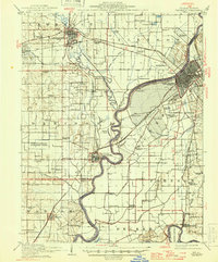
1915 Map of Vincennes
USGS Topo · Published 1946About this map
The Wabash River and Embarrass River dominate this landscape during the mid-1940s, defining the borders between Lawrence County, Illinois, and Knox County, Indiana. The prominent rail hubs of Lawrenceville and Vincennes anchor the region, connected by a dense web of tracks including the Baltimore and Ohio Southwestern RR and the Chicago and Eastern Illinois RR. This survey illustrates a rural society organized around its district schools, with numerous named facilities like Plank Road School, Sand Ridge School, and Crossroads School serving the farming communities. Between the rivers, the geography is marked by drainage systems like the Allison Ditch and Beaver Pond Ditch, which reclaimed land from former wetlands. Notable terrain features such as the Vincennes Common and the Sand Barrens south of St Francisville highlight the unique river-bottom ecology of the era.
Find a feature on this map
85 named features on this map. Tap any name to fly to it.
Don’t see what you’re looking for? This feature index may not catch every label — zoom into the map to look around manually.
Map Details
Editions of this 1915 Vincennes Map
5 editions found
Other maps of this area

1901 · Princeton
USGS Topo · 1:62,500

1902 · Ditney
USGS Topo · 1:125,000

1903 · Petersburg
USGS Topo · 1:62,500

1903 · Princeton
USGS Topo · 1:62,500

1903 · Patoka
USGS Topo · 1:125,000

1904 · Mount Carmel
USGS Topo · 1:62,500

1910 · Hardinville
USGS Topo · 1:62,500

1911 · Sumner
USGS Topo · 1:62,500

1913 · Sumner
USGS Topo · 1:62,500

1915 · Vincennes
USGS Topo · 1:62,500