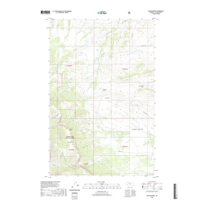
2020 Map of Volcano Reef
USGS Topo · Published 2020About this map
The eastern front of the Sawtooth Range dominates this portion of Teton County, where the plains meet the steep topography of the Lewis & Clark National Forest. The map is characterized by a series of dramatic coulees and canyons that drain the mountain front, including the prominent Blackleaf Canyon and the curiously named Mt Frazier-Chicken Coulee. These features represent the complex geology of the Volcano Reef area, where watercourses like Blackleaf Cr and Dupuyer Cr have carved deep incisions into the landscape. Rural access is defined by remote routes such as Blackleaf Rd and Evan Campbell Rd, which serve a territory largely defined by drainage systems and topographic landmarks rather than established townships. This survey provides a precise record of the land-grant boundaries and private-block sections (PB) that neighbor the national forest boundary.
Find a feature on this map
31 named features on this map. Tap any name to fly to it.
Don’t see what you’re looking for? This feature index may not catch every label — zoom into the map to look around manually.
Map Details
Editions of this 2020 Volcano Reef Map
This is the sole edition of this map. No revisions or reprints were ever made.
Other maps of this area

1903 · Saypo
USGS Topo · 1:125,000

1914 · Heart Butte
USGS Topo · 1:125,000

1918 · Heart Butte
USGS Topo · 1:125,000

1955 · Choteau
USGS Topo · 1:250,000

1957 · Choteau
USGS Topo · 1:250,000

1958 · Choteau
USGS Topo · 1:250,000

1958 · Cave Mountain
USGS Topo · 1:24,000

1958 · Mount Wright
USGS Topo · 1:24,000
1958 · Twin Lakes
USGS Topo · 1:24,000

1960 · Cut Bank
USGS Topo · 1:250,000