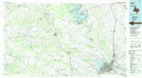
1985 Map of Waco
USGS Topo · Published 1985About this map
Lake Whitney and the surrounding river valleys anchor this mid-1980s landscape, illustrating a region defined by its complex hydrology and transportation corridors. The Brazos River and its major tributaries, including the North Bosque River, Middle Bosque River, and South Bosque River, carve through the terrain toward the urban center of Waco. The map captures a high degree of rail connectivity, featuring the Missouri Kansas Texas and St Louis Southwestern lines as they intersect near West and Lacy-Lakeview.
Find a feature on this map
100 named features on this map. Tap any name to fly to it.
Don’t see what you’re looking for? This feature index may not catch every label — zoom into the map to look around manually.
Map Details
Editions of this 1985 Waco Map
2 editions found
Other maps of this area

1887 · Lampasas
USGS Topo · 1:125,000

1888 · Hamilton
USGS Topo · 1:125,000

1888 · Meridian
USGS Topo · 1:125,000

1889 · Granbury
USGS Topo · 1:125,000

1890 · Stephenville
USGS Topo · 1:125,000

1891 · Cleburne
USGS Topo · 1:125,000

1892 · Temple
USGS Topo · 1:125,000

1892 · Waco
USGS Topo · 1:125,000

1894 · Hamilton
USGS Topo · 1:125,000

1894 · Meridian
USGS Topo · 1:125,000