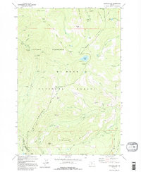
1979 Map of Wahtum Lake
USGS Topo · Published 1995About this map
Benson Plateau and the high ridges of the Waucoma Ridge dominate this section of the Columbia Wilderness as it appeared in the late 1970s. The landscape is defined by the steep drainage basins of Herman Creek and Eagle Creek, where numerous falls occur, including the notable Tunnel Falls. This survey documents the intersection of high-elevation recreation and resource management, showing the Pacific Crest National Scenic Trail winding past Chinidere Mtn and Wahtum Lake. While much of the area is protected within the Mount Hood National Forest, evidence of utility and transport remains in the form of multiple 4wd tracks and the Bull Run Watershed Management Area boundary. Key landmarks for hikers and historians include the Indian Springs Campground and distinctive geological formations like Indianhead Rock and Sawtooth Mountain.
Find a feature on this map
64 named features on this map. Tap any name to fly to it.
Don’t see what you’re looking for? This feature index may not catch every label — zoom into the map to look around manually.
Map Details
Editions of this 1979 Wahtum Lake Map
2 editions found
Other maps of this area

1924 · Mount Hood
USGS Topo · 1:125,000

1926 · Hood River
USGS Topo · 1:125,000

1927 · Mount Hood
USGS Topo · 1:125,000

1929 · Hood River
USGS Topo · 1:125,000

1953 · The Dalles
USGS Topo · 1:250,000

1956 · The Dalles
USGS Topo · 1:250,000

1957 · The Dalles
USGS Topo · 1:250,000

1957 · Bonneville Dam
USGS Topo · 1:62,500

1957 · Hood River
USGS Topo · 1:62,500
1962 · Hickman Butte
USGS Topo · 1:24,000