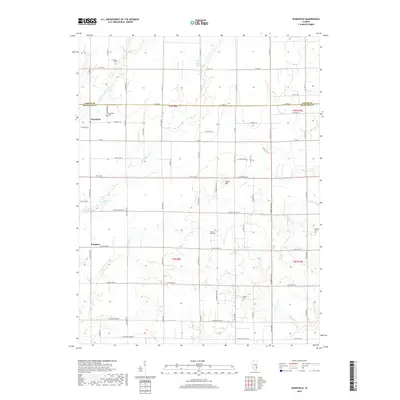
2018 Map of Wakefield
USGS Topo · Published 2018About this map
The small unincorporated community of Wakefield sits on the border of Richland and Jasper Counties, surrounded by a landscape defined by small watercourses and family burial grounds. This rural interior of Illinois features a network of creeks, including Sugar Cr and Hurricane Cr, which drain into localized basins like Nix Lake and Berry Lake. The map reveals the long-standing importance of local genealogy through several established cemeteries such as Pleasant View Cem and Hankins Cem, which serve as landmarks in an area dominated by agricultural fields and county roads. To the south, the settlement of Passport is positioned near Jesse Cr, while the prominence of Onion Hill provides one of the few significant elevation changes in the otherwise steady terrain of the southern Illinois prairie.
Find a feature on this map
70 named features on this map. Tap any name to fly to it.
Don’t see what you’re looking for? This feature index may not catch every label — zoom into the map to look around manually.
Map Details
Editions of this 2018 Wakefield Map
This is the sole edition of this map. No revisions or reprints were ever made.
Other maps of this area

1941 · Newton
USGS Topo · 1:62,500

1943 · Newton
USGS Topo · 1:62,500

1948 · Flora
USGS Topo · 1:62,500

1949 · Olney
USGS Topo · 1:62,500

1949 · Flora
USGS Topo · 1:62,500

1953 · Sailor Springs
USGS Topo · 1:62,500

1958 · Belleville
USGS Topo · 1:250,000

1962 · Belleville
USGS Topo · 1:250,000

1970 · Clay City
USGS Topo · 1:24,000
1971 · Olney
USGS Topo · 1:24,000