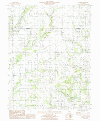
1985 Map of Wakefield
USGS Topo · Published 1985About this map
Wakefield and the settlement of Passport anchor this 1985 survey of the Richland and Jasper County border. The landscape is defined by a dense network of small waterways, including Hurricane Creek, East Fork Wetweather Creek, and Sugar Creek, which carve through the rural townships of Smallwood and Denver. The presence of an Oil Field and a crossing Pipeline in the southern portion near Olney points to the region's energy production history during the mid-to-late 20th century.
Find a feature on this map
25 named features on this map. Tap any name to fly to it.
Don’t see what you’re looking for? This feature index may not catch every label — zoom into the map to look around manually.
Map Details
Editions of this 1985 Wakefield Map
This is the sole edition of this map. No revisions or reprints were ever made.
Other maps of this area

1941 · Newton
USGS Topo · 1:62,500

1943 · Newton
USGS Topo · 1:62,500

1948 · Flora
USGS Topo · 1:62,500

1949 · Olney
USGS Topo · 1:62,500

1949 · Flora
USGS Topo · 1:62,500

1953 · Sailor Springs
USGS Topo · 1:62,500

1958 · Belleville
USGS Topo · 1:250,000

1962 · Belleville
USGS Topo · 1:250,000

1970 · Clay City
USGS Topo · 1:24,000
1971 · Olney
USGS Topo · 1:24,000