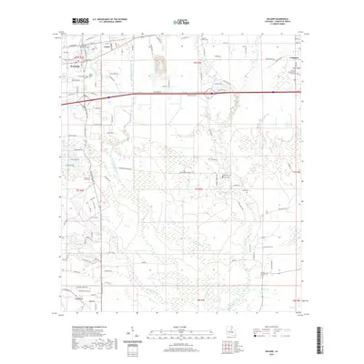
2020 Map of Walker
USGS Topo · Published 2020About this map
Walker and Livingston serve as the primary anchors for this Livingston Parish landscape, where the Livingston Parish District Courthouse marks the local seat of government. The area is characterized by a dense network of bayous and creeks, including Middle Colyell Cr, Prairie Bayou, and Hornsby Cr, which dictate the placement of early road networks like Florida Blvd. For genealogists, the map is particularly detailed regarding burial sites and religious centers, documenting numerous local landmarks such as Satsuma Baptist Cem, Plainview Church Cem, and Colyell Baptist Cem. The transition from the more developed corridor near Corbin to the wetlands in the south reveals the traditional settlement patterns of the Louisiana Florida Parishes, where high ground along the stream divides supported the growth of these historic communities.
Find a feature on this map
85 named features on this map. Tap any name to fly to it.
Don’t see what you’re looking for? This feature index may not catch every label — zoom into the map to look around manually.
Map Details
Editions of this 2020 Walker Map
This is the sole edition of this map. No revisions or reprints were ever made.
Other maps of this area

1934 · Denham Springs
USGS Topo · 1:62,500

1934 · Springfield
USGS Topo · 1:62,500

1939 · Springfield
USGS Topo · 1:62,500

1939 · Denham Springs
USGS Topo · 1:62,500

1942 · Watson
USGS Topo · 1:31,680

1942 · Satsuma
USGS Topo · 1:31,680

1950 · Doyle
USGS Topo · 1:31,680

1953 · Walker
USGS Topo · 1:24,000
1953 · Prairieville
USGS Topo · 1:24,000
1953 · French Settlement
USGS Topo · 1:24,000