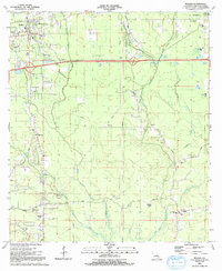
1991 Map of Walker
USGS Topo · Published 1991About this map
The town of Walker and the parish seat at Livingston anchor this Livingston Parish landscape, where the local economy and social life are tied to the intricate drainage of the Colyell Creek system. The map documents a dense network of country churches and schools, including the Doyle Sch and Frost Sch, alongside numerous family-named landmarks like Minton Cem and Wheat Cem. A distinct pattern of rural development is visible in the proliferation of trailer parks and small settlements such as Suma and Walker. The terrain is defined by the winding paths of Middle Colyell Creek, West Colyell Creek, and Little Colyell Creek, which move through the lowlands south of the primary east-west corridors. This 1991 snapshot captures the area just as the industrial and residential footprint was expanding near the Livingston Parish Special Education Center and local infrastructure like the Radio Tower (WVKJ).
Find a feature on this map
40 named features on this map. Tap any name to fly to it.
Don’t see what you’re looking for? This feature index may not catch every label — zoom into the map to look around manually.
Map Details
Editions of this 1991 Walker Map
This is the sole edition of this map. No revisions or reprints were ever made.
Other maps of this area

1934 · Denham Springs
USGS Topo · 1:62,500

1934 · Springfield
USGS Topo · 1:62,500

1939 · Springfield
USGS Topo · 1:62,500

1939 · Denham Springs
USGS Topo · 1:62,500

1942 · Watson
USGS Topo · 1:31,680

1942 · Satsuma
USGS Topo · 1:31,680

1950 · Doyle
USGS Topo · 1:31,680

1953 · Walker
USGS Topo · 1:24,000
1953 · Prairieville
USGS Topo · 1:24,000
1953 · French Settlement
USGS Topo · 1:24,000