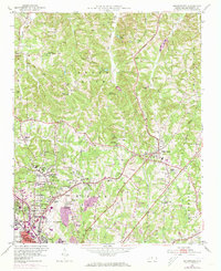
1951 Map of Walkertown
USGS Topo · Published 1973About this map
The northern expansion of Winston-Salem meets the rural Piedmont landscape of Forsyth County in this mid-century topographic record. The industrial and educational character of the region is evident in landmarks like the Smith Reynolds Airport and the Memorial Industrial Sch, while the rural interior is dotted with numerous small community centers such as Walkertown, Oak Grove, and Dennis. This map reflects a transitional era where traditional rural life, represented by numerous country churches like Red Bank Ch and Shiloh Ch, exists alongside early suburban developments such as Montview and Brookwood. The topography is defined by the headwaters of several drainages, including Buffalo Creek and Belews Creek, while the Norfolk and Western and Southern rail lines provide a glimpse into the transportation networks that shaped these North Carolina communities.
Find a feature on this map
71 named features on this map. Tap any name to fly to it.
Don’t see what you’re looking for? This feature index may not catch every label — zoom into the map to look around manually.
Map Details
Editions of this 1951 Walkertown Map
5 editions found
Other maps of this area

1950 · Winston-Salem West
USGS Topo · 1:24,000

1950 · Winston-Salem East
USGS Topo · 1:24,000

1951 · Winston-Salem West
USGS Topo · 1:24,000

1951 · Winston-Salem East
USGS Topo · 1:24,000

1951 · Rural Hall
USGS Topo · 1:24,000

1951 · Walkertown
USGS Topo · 1:24,000

1953 · Winston-Salem
USGS Topo · 1:250,000

1955 · Winston-Salem
USGS Topo · 1:250,000

1962 · Winston-Salem
USGS Topo · 1:250,000

1964 · King
USGS Topo · 1:24,000