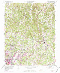
1951 Map of Walkertown
USGS Topo · Published 1984About this map
Smith Reynolds Airport and the expanding northern reaches of Winnston-Salem anchor this mid-century portrait of Forsyth County. The landscape is a mix of urban growth and rural heritage, where small communities like Walkertown and Brookwood are connected by the Norfolk And Western railroad and the Southern line. Significant institutional landmarks are scattered across the terrain, including the Memorial Industrial Sch and several local campuses like Oak Summit Sch and Carver Sch.
Find a feature on this map
60 named features on this map. Tap any name to fly to it.
Don’t see what you’re looking for? This feature index may not catch every label — zoom into the map to look around manually.
Map Details
Editions of this 1951 Walkertown Map
5 editions found
Other maps of this area

1950 · Winston-Salem West
USGS Topo · 1:24,000

1950 · Winston-Salem East
USGS Topo · 1:24,000

1951 · Winston-Salem West
USGS Topo · 1:24,000

1951 · Winston-Salem East
USGS Topo · 1:24,000

1951 · Rural Hall
USGS Topo · 1:24,000

1951 · Walkertown
USGS Topo · 1:24,000

1953 · Winston-Salem
USGS Topo · 1:250,000

1955 · Winston-Salem
USGS Topo · 1:250,000

1962 · Winston-Salem
USGS Topo · 1:250,000

1964 · King
USGS Topo · 1:24,000