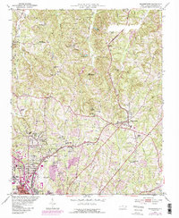
1951 Map of Walkertown
USGS Topo · Published 1987About this map
The northern fringes of Winston-Salem and the rural community of Walkertown define this landscape during a period of transition. The Norfolk and Western and Southern railroads bisect the terrain, facilitating industrial sites like Ogburn Sta and the Memorial Industrial Sch. The southern portion of the sheet shows the expansion of neighborhoods like Montview and Brookwood, while the northern reaches remain dominated by agricultural land and small creeks such as Buffalo Creek and Old Mill Branch. Local history is deeply rooted in the many small congregational centers like Western Pleasant Hope Ch and Bethlehem Ch, which anchor the crossroads along with family burial grounds such as Banner Cem. The presence of the Smith Reynolds Airport and various radio towers reflects the mid-century modernization of Forsyth County.
Find a feature on this map
59 named features on this map. Tap any name to fly to it.
Don’t see what you’re looking for? This feature index may not catch every label — zoom into the map to look around manually.
Map Details
Editions of this 1951 Walkertown Map
5 editions found
Other maps of this area

1950 · Winston-Salem West
USGS Topo · 1:24,000

1950 · Winston-Salem East
USGS Topo · 1:24,000

1951 · Winston-Salem West
USGS Topo · 1:24,000

1951 · Winston-Salem East
USGS Topo · 1:24,000

1951 · Rural Hall
USGS Topo · 1:24,000

1951 · Walkertown
USGS Topo · 1:24,000

1953 · Winston-Salem
USGS Topo · 1:250,000

1955 · Winston-Salem
USGS Topo · 1:250,000

1962 · Winston-Salem
USGS Topo · 1:250,000

1964 · King
USGS Topo · 1:24,000