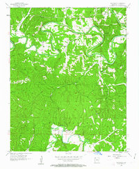
1957 Map of War Eagle
USGS Topo · Published 1963About this map
White River and War Eagle Creek define the landscape of this Benton County region during the late 1950s. The settlement of War Eagle serves as a focal point near the confluence of these winding waterways, where the War Eagle Ch and the neighboring community of Larue anchor the local rural social life. The map captures a transition period for the river valley before later development, showing active landmarks like Knox Ferry and numerous family-named burial grounds including Webb Cem and Hatfield Cem. Educational life is scattered across the hills at Coal Gap Sch, Rocky Branch Sch, and Shady Grove Sch. The intricate network of hollows and branches, such as Ventris Hollow and Shaddox Branch, reveals a topography where geography dictated the placement of early Benton County homesteads and roads.
Find a feature on this map
43 named features on this map. Tap any name to fly to it.
Don’t see what you’re looking for? This feature index may not catch every label — zoom into the map to look around manually.
Map Details
Editions of this 1957 War Eagle Map
4 editions found

Other maps of this area

1899 · Fayetteville
USGS Topo · 1:125,000

1900 · Eureka Springs
USGS Topo · 1:125,000

1901 · Eureka Springs
USGS Topo · 1:125,000

1901 · Fayetteville
USGS Topo · 1:125,000

1904 · Fayetteville
USGS Topo · 1:125,000

1945 · Harrison
USGS Topo · 1:250,000

1949 · Harrison
USGS Topo · 1:250,000

1954 · Harrison
USGS Topo · 1:250,000

1954 · Tulsa
USGS Topo · 1:250,000

1957 · Mundell
USGS Topo · 1:24,000