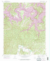
1957 Map of War Eagle
USGS Topo · Published 1977About this map
War Eagle Creek and the White River converge in this Arkansas landscape, documenting the region shortly after the mid-century creation of Beaver Lake. The 1976 purple revisions highlight the lake's expanded shoreline and its transformation of the river valley, now featuring the Ventris Public Use Area and Rocky Branch Public Use Area. Despite the rise of the reservoir, older rural landmarks remain clearly marked, including the War Eagle settlement and the War Eagle Ch.
Find a feature on this map
31 named features on this map. Tap any name to fly to it.
Don’t see what you’re looking for? This feature index may not catch every label — zoom into the map to look around manually.
Map Details
Editions of this 1957 War Eagle Map
4 editions found

Other maps of this area

1899 · Fayetteville
USGS Topo · 1:125,000

1900 · Eureka Springs
USGS Topo · 1:125,000

1901 · Eureka Springs
USGS Topo · 1:125,000

1901 · Fayetteville
USGS Topo · 1:125,000

1904 · Fayetteville
USGS Topo · 1:125,000

1945 · Harrison
USGS Topo · 1:250,000

1949 · Harrison
USGS Topo · 1:250,000

1954 · Harrison
USGS Topo · 1:250,000

1954 · Tulsa
USGS Topo · 1:250,000

1957 · Mundell
USGS Topo · 1:24,000