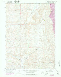
1962 Map of Warfield Creek
USGS Topo · Published 1979About this map
The high ridge of the Bear River Divide dominates this portion of Lincoln County, marking the topographical split between major western drainage systems. To the east, the industrial imprint of the Elkol Strip Mine cuts into the slopes near Cavanaugh Peak, while the western drainage is defined by the headwaters of Warfield Creek and Little Muddy Creek. This 1962 survey, updated with 1970s revisions, illustrates a remote ranching and resource extraction landscape. Traces of human habitation are sparse but notable, specifically the Old Dutch John Ranch situated along the South Fork Twin Creek. The map also records essential water sources for livestock and local wildlife, such as Warfield Springs and the Skull Point Res, which are connected by a network of unimproved roads and a dedicated Trail through the hollows.
Find a feature on this map
14 named features on this map. Tap any name to fly to it.
Don’t see what you’re looking for? This feature index may not catch every label — zoom into the map to look around manually.
Map Details
Editions of this 1962 Warfield Creek Map
2 editions found
Other maps of this area

1954 · Sage
USGS Topo · 1:62,500

1954 · Ogden
USGS Topo · 1:250,000

1954 · Kemmerer
USGS Topo · 1:62,500

1958 · Ogden
USGS Topo · 1:250,000

1960 · Ogden
USGS Topo · 1:250,000

1962 · Bell Butte NE
USGS Topo · 1:24,000

1962 · Cumberland Gap
USGS Topo · 1:24,000

1962 · Elkol SW
USGS Topo · 1:24,000

1962 · Elkol
USGS Topo · 1:24,000

1962 · Warfield Creek
USGS Topo · 1:24,000