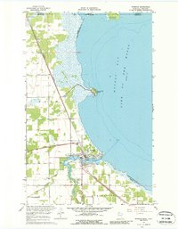
1967 Map of Warroad
USGS Topo · Published 1988About this map
Warroad serves as a critical northern port and border entry point at the southwestern edge of Lake of the Woods in this late-1960s survey. The landscape is defined by the intersection of international logistics and water-dependent industry, featuring the US Customhouse near the Manitoba Minnesota line and the Canadian National railway tracking south from the border. The town itself is situated where the Warroad River meets Muskeg Bay, supporting local landmarks like Lakeview Park and a Gaging Station on the riverbank.
Find a feature on this map
32 named features on this map. Tap any name to fly to it.
Don’t see what you’re looking for? This feature index may not catch every label — zoom into the map to look around manually.
Map Details
Editions of this 1967 Warroad Map
3 editions found
Other maps of this area

1918 · Buffalo Bay
USGS Topo · 1:62,500

1918 · Roosevelt
USGS Topo · 1:62,500

1918 · Warroad
USGS Topo · 1:62,500

1943 · Roosevelt
USGS Topo · 1:62,500

1943 · Warroad
USGS Topo · 1:62,500

1954 · Roseau
USGS Topo · 1:250,000

1957 · Roseau
USGS Topo · 1:250,000

1958 · Roseau
USGS Topo · 1:250,000

1963 · Kenora
USGS Topo · 1:250,000

1967 · Roosevelt NW
USGS Topo · 1:24,000