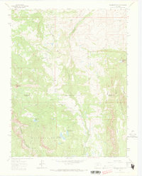
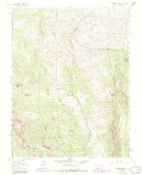
1963 Map of Washboard Rock
USGS Topo · Published 1973About this map
The Cimarron River carves through the heart of this high-elevation landscape, where the Uncompahgre National Forest spans several county lines. This mid-century survey captures a region defined by ranching and water management, anchored by the Big Cimarron Ranch and the early infrastructure of Fish Creek Reservoir No 1 and Fish Creek Reservoir No 2. Numerous alpine lakes and seasonal creeks dot the topography, providing a detailed look at the hydrology of the area before modern developments changed the character of the back-country.
Find a feature on this map
32 named features on this map. Tap any name to fly to it.
Don’t see what you’re looking for? This feature index may not catch every label — zoom into the map to look around manually.
Map Details
Editions of this 1963 Washboard Rock Map
5 editions found
Other maps of this area

1902 · Ouray
USGS Topo · 1:62,500

1903 · Lake City
USGS Topo · 1:62,500

1904 · Ouray
USGS Topo · 1:62,500

1905 · Lake City
USGS Topo · 1:62,500

1908 · Uncompahgre
USGS Topo · 1:125,000

1909 · Montrose
USGS Topo · 1:125,000

1911 · Uncompahgre
USGS Topo · 1:125,000

1911 · Montrose
USGS Topo · 1:125,000

1956 · Curecanti Needle
USGS Topo · 1:24,000

1956 · Cimarron
USGS Topo · 1:24,000