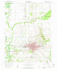
1957 Map of Washington
USGS Topo · Published 1958About this map
Washington stands as a significant regional hub in Daviess County during the late 1950s, defined by its central grid and dual-railroad infrastructure. The convergence of the Baltimore And Ohio and the New York Central railroads at the city center underscores the era's reliance on rail transport for both industry and local commerce. Beyond the urban core, the landscape transitions into a network of drainage ditches and family landmarks, such as Toms Hill and Hyatt Island along the winding White River. Local history is deeply etched into the countryside through numerous small burying grounds and community centers, including St Johns Cem and the Sugarland Sch. This survey provides a clear view of the rural-industrial balance, where the expansive Colbert Ditch and Prairie Creek manage the fertile lowlands surrounding established pockets like Maysville and South Washington.
Find a feature on this map
52 named features on this map. Tap any name to fly to it.
Don’t see what you’re looking for? This feature index may not catch every label — zoom into the map to look around manually.
Map Details
Editions of this 1957 Washington Map
4 editions found
Other maps of this area

1943 · Bicknell
USGS Topo · 1:24,000

1943 · Plainville
USGS Topo · 1:24,000

1943 · Epsom
USGS Topo · 1:24,000

1944 · Montgomery
USGS Topo · 1:24,000

1944 · Glendale
USGS Topo · 1:24,000

1944 · Washington
USGS Topo · 1:24,000

1944 · Monroe City
USGS Topo · 1:24,000

1944 · Wheatland
USGS Topo · 1:24,000

1945 · Sandy Hook
USGS Topo · 1:24,000

1956 · Vincennes
USGS Topo · 1:250,000