
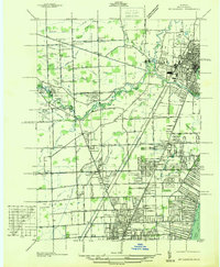
1936 Map of Washington
USGS Topo · Published 1936About this map
The Packard Proving Grounds dominate the landscape of Shelby Township in this 1930s survey, marking a significant era of automotive testing along State Highway No 53. The terrain is defined by the Clinton River and its intricate drainage network, including the Yates Mill Stream and Middle Branch, which supported early industrial and agricultural development. To the south, the Ferry Morse Seed Co Farms and Brooklands Subdivision illustrate the transition from large-scale cultivation to residential expansion near Utica.
Find a feature on this map
76 named features on this map. Tap any name to fly to it.
Don’t see what you’re looking for? This feature index may not catch every label — zoom into the map to look around manually.
Map Details
Editions of this 1936 Washington Map
This is the sole edition of this map. No revisions or reprints were ever made.
Other maps of this area

1908 · Rochester
USGS Topo · 1:62,500

1912 · Mt Clemens
USGS Topo · 1:62,500

1914 · Armada
USGS Topo · 1:62,500

1928 · Armada
USGS Topo · 1:62,500

1929 · Mt Clemens
USGS Topo · 1:62,500

1936 · Warren
USGS Topo · 1:31,680

1936 · Birmingham
USGS Topo · 1:31,680

1936 · Rochester
USGS Topo · 1:31,680

1936 · Waldenburg
USGS Topo · 1:31,680
1936 · Mt Clemens
USGS Topo · 1:31,680
Featured Places
- Sterling Heights, MI
- Shelby Charter Township, MI
- Rochester Hills, MI
- Washington Charter Township, MI
- Oakland Charter Township, MI