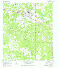
1962 Map of Waskom
USGS Topo · Published 1978About this map
The Greenwood Gas and Oil Field dominates the landscape of the Texas-Louisiana border in this mid-century survey, revealing a region defined by energy extraction and rail transit. Near the state line, Waskom serves as a central hub where the Missouri Pacific railroad cuts through the terrain. Evidence of the petroleum industry is ubiquitous, with numerous wells and an extensive network of pipelines shown alongside a dedicated Gasoline Plant.
Find a feature on this map
42 named features on this map. Tap any name to fly to it.
Don’t see what you’re looking for? This feature index may not catch every label — zoom into the map to look around manually.
Map Details
Editions of this 1962 Waskom Map
4 editions found
Other maps of this area

1943 · Waskom
USGS Topo · 1:62,500

1944 · Caddo Lake
USGS Topo · 1:62,500

1945 · Waskom
USGS Topo · 1:62,500

1945 · Greenwood
USGS Topo · 1:62,500

1946 · Caddo Lake
USGS Topo · 1:62,500

1948 · Mooringsport
USGS Topo · 1:62,500

1955 · Shreveport
USGS Topo · 1:250,000

1955 · Mooringsport
USGS Topo · 1:62,500

1955 · Greenwood
USGS Topo · 1:62,500

1956 · Shreveport
USGS Topo · 1:250,000