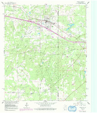
1962 Map of Waskom
USGS Topo · Published 1992About this map
The borderlands of Harrison County, Texas, and Caddo Parish, Louisiana, come into focus in this mid-century survey, revealing a landscape defined by the Elysian Fields and Greenwood Gas Field. The settlement of Waskom serves as a central hub, featuring local landmarks like Abney High School, Lions Club Park, and Restland Cemetery. This region is a complex web of industrial infrastructure, with numerous pipelines and a Gasoline Plant supporting the local energy economy.
Find a feature on this map
33 named features on this map. Tap any name to fly to it.
Don’t see what you’re looking for? This feature index may not catch every label — zoom into the map to look around manually.
Map Details
Editions of this 1962 Waskom Map
4 editions found
Other maps of this area

1943 · Waskom
USGS Topo · 1:62,500

1944 · Caddo Lake
USGS Topo · 1:62,500

1945 · Waskom
USGS Topo · 1:62,500

1945 · Greenwood
USGS Topo · 1:62,500

1946 · Caddo Lake
USGS Topo · 1:62,500

1948 · Mooringsport
USGS Topo · 1:62,500

1955 · Shreveport
USGS Topo · 1:250,000

1955 · Mooringsport
USGS Topo · 1:62,500

1955 · Greenwood
USGS Topo · 1:62,500

1956 · Shreveport
USGS Topo · 1:250,000