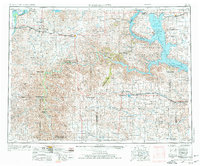
1953 Map of Watford City
USGS Topo · Published 1976About this map
Lake Sakakawea dominates the eastern half of this landscape, a massive reservoir created by the damming of the Missouri River. The waters reach deep into the Fort Berthold Indian Reservation, altering the geography where the river once flowed freely near settlements like New Town. To the west, the badlands topography is preserved within the Theodore Roosevelt National Memorial Park (North Unit) and its South Unit, featuring unique landmarks such as the Petrified Forest.
Find a feature on this map
67 named features on this map. Tap any name to fly to it.
Don’t see what you’re looking for? This feature index may not catch every label — zoom into the map to look around manually.
Map Details
Editions of this 1953 Watford City Map
3 editions found
Other maps of this area

1909 · Glendive
USGS Topo · 1:250,000

1911 · Ray
USGS Topo · 1:125,000

1953 · Miles City
USGS Topo · 1:250,000

1953 · Williston
USGS Topo · 1:250,000

1953 · Dickinson
USGS Topo · 1:250,000

1953 · Watford City
USGS Topo · 1:250,000

1954 · Minot
USGS Topo · 1:250,000

1954 · Glendive
USGS Topo · 1:250,000

1954 · Wolf Point
USGS Topo · 1:250,000

1954 · Bismarck
USGS Topo · 1:250,000