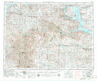
1953 Map of Watford City
USGS Topo · Published 1980About this map
Lake Sakakawea dominates this western North Dakota landscape, its vast blue fingers reaching into the Fort Berthold Indian Reservation and defining the rugged geography of the mid-20th century. The map illustrates a region where the Missouri River and Yellowstone River converge, supporting small agricultural hubs like Alexander and Arnegard. The terrain is marked by dozens of named landmarks, from the Killdeer Mountains in the south to the Tepee Buttes further west.
Find a feature on this map
50 named features on this map. Tap any name to fly to it.
Don’t see what you’re looking for? This feature index may not catch every label — zoom into the map to look around manually.
Map Details
Editions of this 1953 Watford City Map
3 editions found
Other maps of this area

1909 · Glendive
USGS Topo · 1:250,000

1911 · Ray
USGS Topo · 1:125,000

1953 · Miles City
USGS Topo · 1:250,000

1953 · Williston
USGS Topo · 1:250,000

1953 · Dickinson
USGS Topo · 1:250,000

1953 · Watford City
USGS Topo · 1:250,000

1954 · Minot
USGS Topo · 1:250,000

1954 · Glendive
USGS Topo · 1:250,000

1954 · Wolf Point
USGS Topo · 1:250,000

1954 · Bismarck
USGS Topo · 1:250,000