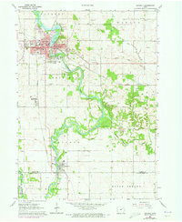
1963 Map of Waverly
USGS Topo · Published 1973About this map
The Cedar River carves a winding path through this Iowa landscape, connecting the regional hub of Waverly with the southern settlement of Janesville. In the heart of Waverly, Wartburg College and the Courthouse stand as central landmarks, while the city's growth is charted through several residential and institutional sites like Mercy Hospital and the sprawling Harlington Cemetery. The river valley is flanked by active industrial and recreational sites, including several Quarries and the riverside Camp Sacajawea.
Find a feature on this map
50 named features on this map. Tap any name to fly to it.
Don’t see what you’re looking for? This feature index may not catch every label — zoom into the map to look around manually.
Map Details
Editions of this 1963 Waverly Map
Other maps of this area

1954 · Waterloo
USGS Topo · 1:250,000

1955 · Waterloo
USGS Topo · 1:250,000

1963 · Waverly
USGS Topo · 1:24,000

1963 · Denver
USGS Topo · 1:24,000

1963 · Cedar Falls
USGS Topo · 1:24,000

1963 · Waterloo North
USGS Topo · 1:24,000

1971 · Shell Rock
USGS Topo · 1:24,000

1971 · Bremer
USGS Topo · 1:24,000

1971 · Plainfield
USGS Topo · 1:24,000

1971 · Tripoli
USGS Topo · 1:24,000