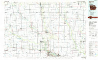
1984 Map of Waverly
USGS Topo · Published 1985About this map
The Shell Rock River and Cedar River dominate this 1984 planimetric study of northeast Iowa, carving paths through a landscape defined by agricultural drainage and river-town development. This era shows Cedar Falls and Waterloo as significant regional hubs, with the University of Northern Iowa established as a central landmark. The map tracks the extensive rail network of the Chicago and North Western as it connects smaller grain-handling settlements like Dumont, Allison, and Parkersburg.
Find a feature on this map
95 named features on this map. Tap any name to fly to it.
Don’t see what you’re looking for? This feature index may not catch every label — zoom into the map to look around manually.
Map Details
Editions of this 1984 Waverly Map
2 editions found
Other maps of this area

1901 · Oelwein
USGS Topo · 1:125,000

1903 · Winthrop
USGS Topo · 1:125,000

1906 · Decorah
USGS Topo · 1:125,000

1954 · Mason City
USGS Topo · 1:250,000

1954 · Waterloo
USGS Topo · 1:250,000

1955 · Waterloo
USGS Topo · 1:250,000

1957 · Mason City
USGS Topo · 1:250,000

1958 · Mason City
USGS Topo · 1:250,000

1958 · La Crosse
USGS Topo · 1:250,000

1959 · Mason City
USGS Topo · 1:62,500