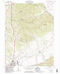
1992 Map of Waverly North
USGS Topo · Published 1995About this map
The Scioto River dominates this landscape on the border of Ross and Pike counties, carving a wide valley through the dense woodlands of the Scioto Trail State Forest. To the south, the community of Waverly and the adjacent Bristol Village sit near the confluence of Crooked Creek and the river, showing the expansion of residential patterns in the early 1990s. An interesting remnant of 19th-century infrastructure is visible in the southern portion of the map, where the Erie Canal (Abandoned) runs parallel to the river near Omega.
Find a feature on this map
64 named features on this map. Tap any name to fly to it.
Don’t see what you’re looking for? This feature index may not catch every label — zoom into the map to look around manually.
Map Details
Editions of this 1992 Waverly North Map
This is the sole edition of this map. No revisions or reprints were ever made.
Other maps of this area

1906 · Waverly
USGS Topo · 1:62,500

1906 · Chillicothe
USGS Topo · 1:62,500

1908 · Chillicothe
USGS Topo · 1:62,500

1908 · Waverly
USGS Topo · 1:62,500

1912 · Roxabell
USGS Topo · 1:62,500

1914 · Roxabell
USGS Topo · 1:62,500

1915 · Piketon
USGS Topo · 1:62,500

1917 · Piketon
USGS Topo · 1:62,500

1944 · Piketon
USGS Topo · 1:62,500

1944 · Roxabell
USGS Topo · 1:62,500