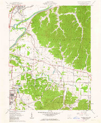
1961 Map of Waverly South
USGS Topo · Published 1963About this map
The U S Reservation and Atomic Energy Commission facilities dominate the southwestern landscape of this early 1960s survey, representing a significant federal footprint in the region. To the east, the sprawling woodlots of the Wayne National Forest cover the terrain, punctuated by deep hollows like Bandy Hollow and Jenkins Hollow. The Scioto River valley serves as a primary corridor for transportation and settlement, hosting the Norfolk and Western and Chesapeake and Ohio railroads. Genealogy interest is high throughout the quadrangle, with numerous family-named burial grounds such as Brust No 2 Cem, Lucas Cem, and Mt Gilead Cem located near small communities like Zahns Corners and Givens. The map also captures infrastructure including a Landing Strip, a Lookout Tower, and the Filtration Plant supporting the government reservation, reflecting the era's industrial and strategic developments.
Find a feature on this map
82 named features on this map. Tap any name to fly to it.
Don’t see what you’re looking for? This feature index may not catch every label — zoom into the map to look around manually.
Map Details
Editions of this 1961 Waverly South Map
4 editions found
Other maps of this area

1906 · Waverly
USGS Topo · 1:62,500

1908 · Waverly
USGS Topo · 1:62,500

1911 · Sciotoville
USGS Topo · 1:62,500

1913 · Sciotoville
USGS Topo · 1:62,500

1915 · Otway
USGS Topo · 1:62,500

1915 · Piketon
USGS Topo · 1:62,500

1917 · Piketon
USGS Topo · 1:62,500

1917 · Otway
USGS Topo · 1:62,500

1944 · Piketon
USGS Topo · 1:62,500

1947 · Columbus
USGS Topo · 1:250,000