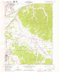
1961 Map of Waverly South
USGS Topo · Published 1979About this map
The Scioto River valley serves as a vital corridor for both natural drainage and industrial transport in this 1961 survey, where the Norfolk and Western and Chesapeake and Ohio railroads parallel the water's edge. This section of Pike County is defined by the significant presence of the U S Reservation Atomic Energy Commission, featuring a filtration plant and large substation near the hills of Shyville.
Find a feature on this map
85 named features on this map. Tap any name to fly to it.
Don’t see what you’re looking for? This feature index may not catch every label — zoom into the map to look around manually.
Map Details
Editions of this 1961 Waverly South Map
4 editions found
Other maps of this area

1906 · Waverly
USGS Topo · 1:62,500

1908 · Waverly
USGS Topo · 1:62,500

1911 · Sciotoville
USGS Topo · 1:62,500

1913 · Sciotoville
USGS Topo · 1:62,500

1915 · Otway
USGS Topo · 1:62,500

1915 · Piketon
USGS Topo · 1:62,500

1917 · Piketon
USGS Topo · 1:62,500

1917 · Otway
USGS Topo · 1:62,500

1944 · Piketon
USGS Topo · 1:62,500

1947 · Columbus
USGS Topo · 1:250,000