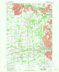
1968 Map of Wayne
USGS Topo · Published 1970About this map
The Lower River Rouge and Middle River Rouge define the hydrological character of this portion of Wayne County, winding through suburban expansion that connects Plymouth, Livonia, and Westland. During the late 1960s, this area transitioned from agricultural parcels to dense residential developments, yet retained significant pockets of local history through landmarks like Riverside Cemetery and Newburgh Cem. The intersection of major rail lines, including the Chesapeake and Ohio Railroad and the Penn Central, provided the industrial backbone for the region's growth.
Find a feature on this map
120 named features on this map. Tap any name to fly to it.
Don’t see what you’re looking for? This feature index may not catch every label — zoom into the map to look around manually.
Map Details
Editions of this 1968 Wayne Map
4 editions found
Other maps of this area

1902 · South Lyon
USGS Topo · 1:62,500

1902 · Ypsilanti
USGS Topo · 1:62,500

1904 · Ann Arbor
USGS Topo · 1:125,000

1905 · Wayne
USGS Topo · 1:62,500

1906 · Ypsilanti
USGS Topo · 1:62,500

1906 · South Lyon
USGS Topo · 1:62,500

1906 · Romulus
USGS Topo · 1:62,500

1908 · Ann Arbor
USGS Topo · 1:125,000

1912 · Wayne
USGS Topo · 1:62,500

1928 · Romulus
USGS Topo · 1:62,500
Featured Places
- Canton Township, MI
- Canton Charter Township, Canton Township
- Livonia, MI
- Westland, MI
- Van Buren Charter Township, MI