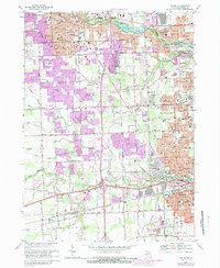
1968 Map of Wayne
USGS Topo · Published 1989About this map
The Middle River Rouge and Lower River Rouge define the hydrological character of this portion of Wayne County, shaping the growth of suburban communities like Plymouth, Livonia, and Westland. Small drain systems such as Deer Drain and Holliday Drain feed into the river valleys, which were preserved as public space through the Middle Rouge Parkway and Newburgh Lake. The landscape reflects a mid-century transition, where residential expansion began to surround established landmarks like the Mettetal Airport and the National Airport.
Find a feature on this map
93 named features on this map. Tap any name to fly to it.
Don’t see what you’re looking for? This feature index may not catch every label — zoom into the map to look around manually.
Map Details
Editions of this 1968 Wayne Map
4 editions found
Other maps of this area

1902 · South Lyon
USGS Topo · 1:62,500

1902 · Ypsilanti
USGS Topo · 1:62,500

1904 · Ann Arbor
USGS Topo · 1:125,000

1905 · Wayne
USGS Topo · 1:62,500

1906 · Ypsilanti
USGS Topo · 1:62,500

1906 · South Lyon
USGS Topo · 1:62,500

1906 · Romulus
USGS Topo · 1:62,500

1908 · Ann Arbor
USGS Topo · 1:125,000

1912 · Wayne
USGS Topo · 1:62,500

1928 · Romulus
USGS Topo · 1:62,500
Featured Places
- Canton Township, MI
- Canton Charter Township, Canton Township
- Livonia, MI
- Westland, MI
- Van Buren Charter Township, MI