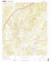
1966 Map of Weir
USGS Topo · Published 1967About this map
The town of Weir serves as a central hub on this mid-1960s survey, positioned at the crossing of the Illinois Central railroad and the Yockanookany River. The landscape is defined by the winding course of the Natchez Trace Parkway as it cuts through the northern sections, passing landmarks like the Bowy Overlook and Roadside Park. This era shows a community deeply rooted in its local institutions, evidenced by the numerous country churches such as Mt Moriah Ch, Millsprings Ch, and New Zion Ch scattered across the hills.
Find a feature on this map
34 named features on this map. Tap any name to fly to it.
Don’t see what you’re looking for? This feature index may not catch every label — zoom into the map to look around manually.
Map Details
Editions of this 1966 Weir Map
2 editions found
Other maps of this area

1953 · West Point
USGS Topo · 1:250,000

1958 · West Point
USGS Topo · 1:250,000

1963 · West Point
USGS Topo · 1:250,000

1966 · Stewart
USGS Topo · 1:24,000

1966 · Weir
USGS Topo · 1:24,000

1966 · Tomnolen
USGS Topo · 1:24,000

1966 · French Camp
USGS Topo · 1:24,000

1968 · Weir
USGS Topo · 1:62,500

1972 · McCool
USGS Topo · 1:24,000

1972 · Highpoint
USGS Topo · 1:24,000